

A line moved before the chord
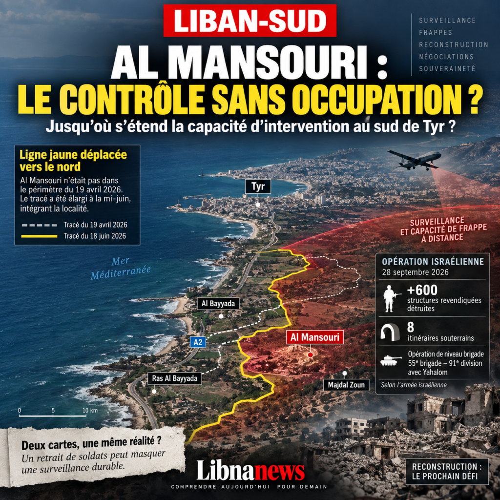
Al Mansouri did not appear in the first map of Israel’s post-war zone of control in southern Lebanon. On 19 April 2026, the town south of Tyre remained outside the perimeter then presented by the Israeli army. Two months later, the situation had changed. On 18 June, the « yellow route » defining the space in which Israeli forces intended to operate was pushed north in the western sector towards Al Bayyada, Majdal Zun and Al Mansouri. The comparison of the maps gives an important indication: Al Mansouri is taken in the new device, whereas it was not part of it before. A Lebanese military official had also indicated at that time that the locality had just been integrated into the area of occupation. Therefore, change is not only a matter of semantic evolution or a new cutting on a map; It corresponds to a concrete change in the terrain from which the security arrangements would then be discussed.
The timetable gives this progress a special scope. Eight days after the displacement of the route, on 26 June, a framework agreement was signed in Washington, D.C., to organize a process of gradual transfer of sectors to the Lebanese army and a gradual Israeli withdrawal, in parallel with measures on non-State weapons and military infrastructure. On the same day as the political framework was in place, Israeli warnings called on the inhabitants of Al Mansuri to leave the area, now considered to be within Israeli operational space. The chronology does not demonstrate that progress was decided solely to create a currency exchange. However, it establishes a much more concrete fact: as the withdrawal began to be organized, its geographical starting point had already been moved northward. A town previously outside the Israeli perimeter became a territory whose evacuation could now enter the negotiation process.
Why Al Mansouri Counts More Than Its Size
The military value of Al Mansouri appears when one stops looking at the village in isolation. The town is located south of Tyre, where the coastal strip begins to connect with the hills and valleys of the interior. Further south are Al Bayyada and Ras Al Bayyada; east and southeast, Majdal Zoun opens on the reliefs. Together, these dots form an arc allowing to observe part of the passages between the coast and the heights. Ras Al Bayyada overlooks the coastal axis from Naqoura. Majdal Zoun offers a depth towards the inside. Al Mansouri extends this architecture northward and brings the surveillance zone closer to the southern sector of Tyre. It is not a question of saying that Tyre is in the process of occupation. Nothing in the available elements allows such a conclusion. The stake is different: the more the device goes up, the more a large portion of the movements south of Tyre can enter a field of observation and military intervention.
This reading is not entirely new in Israeli military thinking. A study of fighting in the western sector during the 1982 war emphasized the value of dominant positions and access from the coast to the hills. The conditions of 1982 cannot, of course, be mechanically transposed to 2026. Forces, weapons, intelligence and the political environment have changed dramatically. The geographical factor remains: an army that holds or observes the heights and entrances of the main axes does not need to occupy each house to limit traffic in the space below. Drones, sensors, imaging and contemporary means of strike further reinforce this logic. Where there was a need for numerous positions and permanent patrols, part of the constraint can now be imposed remotely.
One brigade-level operation and more than 600 claimed structures destroyed
The scale of the operation in Al Mansouri confirms that the locality was considered an important objective. On 28 September, the Israeli army announced the end of several weeks of operations in the area. She indicated that a brigade-level force had been engaged, with elements of the 55th Brigade under the command of the 91st Division and the participation of Yahalom, a specialized engineering unit. According to the Israeli record, more than 600 military structures were destroyed, as well as eight underground routes; Several dozens of launching positions or devices would also have been discovered. These data are statements by the Israeli army and do not constitute independent expertise. However, they are indicative of the Israeli representation of the area: Al Mansouri is not described as a mere point of fire, but as a space where buildings, undergrounds, travel routes and launching devices form a coherent infrastructure.
The paradox comes after this operation. Despite the means involved and the magnitude of the destruction claimed, the scheme does not seem to require a permanent presence equivalent to the heart of the village. This is precisely what gives meaning to the notion of « fire control ». The aim is no longer necessarily to maintain an important unit in each locality, but to destroy infrastructure deemed to be threatening, to improve access observation and to maintain a strike capability against any activity considered a military reconstitution. Such a method reduces the cost of a traditional occupation. It limits the exposure of soldiers, reduces logistical needs and allows military influence to be maintained over an area without direct administration. For Lebanon, however, this development makes it much more difficult to define a true withdrawal.
« Fire control »: what it really changes
In a traditional occupation, the line of control can be observed: soldiers, posts, vehicles, dams and logistics roads indicate where the army’s presence begins and stops. Remote control is much more ambiguous. A force can physically leave a village while monitoring its roads, entrances, construction sites and movements between the coast and the hills. In addition, if it retains a rapid response capability by drone, artillery or aviation, the territory may return formally under Lebanese authority while remaining subject to external coercion. The difference is decisive: recovering a military position does not automatically mean regaining full freedom to use territory.
In Al Mansouri, this question is not theoretical. On 7 October, while discussions on future arrangements are continuing, Israeli artillery fire again targeted the locality and automatic gunfire was reported towards its surroundings. These operations are part of a broader series of actions in the South Lebanon. They show that the sector remains militarily active after the September operation. For the inhabitants, the distinction between occupation and armed surveillance can therefore become very concrete: a house can be found in Lebanese territory without its owner being sure to be able to rebuild it; a road may be opened without the vehicles passing through escaping observation; an agricultural parcel may be accessible while remaining exposed to intervention. Sovereignty is no longer measured solely by the presence of a flag or military post, but by the real capacity of the inhabitants and institutions to act without the implied authorization of an external power.
The Territory as a starting point for negotiations
Progress towards Al Mansouri also raises the question of the relationship between military conquest and negotiation. The 26 June agreement does not provide for an instant withdrawal to the international border. It is based on a gradual logic, with sectors gradually transferred to the Lebanese army and steps related to security commitments. In this type of mechanism, any prior change in the terrain has a political effect. If an army advances before the agreement, the newly controlled space then falls into the category of territories from which it may withdraw. Withdrawal becomes a measurable and possibly conditional step. This still does not make it possible to say that the only objective of the advance was to produce a negotiating card, but this shows that the military gain is changing the ratio of diplomatic force.
This mechanism explains part of the divergence between Beirut and Israel. For Lebanon, withdrawal must lead to the restoration of sovereignty and the termination of Israeli operations in its territory. For Israel, withdrawals appear to be linked to the verification of security conditions and the prevention of the rebuilding of Hezbollah’s capabilities. Until these two definitions are reconciled, an evacuated area may remain in dispute in its use. Israel may consider that it has withdrawn since it does not maintain more soldiers there; Lebanon may consider the withdrawal incomplete if the strikes, incursions or de facto prohibitions continue. Al Mansouri then becomes a test: will the future agreement only concern the location of the forces, or also the rules that will apply after their departure?
The Lebanese Army at the centre of an operational contradiction
The role of the Lebanese Armed Forces is essential. It must take over the areas evacuated, prevent the reconstruction of non-State military infrastructure and restore an effective public authority. But this mission assumes that the army itself has operational control. If Israel retains unilateral freedom of action, there is an immediate contradiction. The Lebanese army could consider a construction site civilian while Israel would call it a threat. It could see the lack of military activity in a sector while Israeli intelligence would support the opposite. It could secure a road without ensuring that a vehicle will not be targeted on the basis of information it does not have access to. The problem, therefore, is not just how many Lebanese soldiers will be deployed, but what prerogatives will be truly recognized.
This issue joins the broader transformation of the discussions on the South. The file is no longer limited to the removal of specific positions. It has a security architecture that includes surveillance, intelligence, infrastructure control, verification mechanisms and the American role. Several Lebanese officials now describe the risk of the management of the South slipping from a simple withdrawal problem to a much wider military and security arrangement under external supervision. Such developments could provide mechanisms for preventing incidents, but could also institutionalize a situation in which Lebanese sovereignty remained conditional on permanent verification and authorization. It will depend on the precise content of the mechanisms chosen.
Reconstruction, next battle of Al Mansouri
The most concrete problem will appear when rebuilding. After the destruction, the return of the inhabitants requires much more than the opening of the roads. We need to clear the rubble, repair electricity and water, rebuild housing, restore agricultural land and restore shops. Each of these acts produces visible movements: earth-moving machinery, excavations, trucks of materials, new buildings and road works. In an area where Israel claims to have destroyed underground routes and military infrastructure, there is a risk of ongoing suspicion of civilian reconstruction. Without a common verification mechanism, excavation for a water system can be interpreted as the beginning of an underground work; a building can be considered a military infrastructure; a road site can be monitored as a modification of the land.
Time then becomes a silent weapon. If the inhabitants cannot rebuild quickly, some of them will remain elsewhere. Economic activities will move with them, schools will lose students and agricultural land may be less exploited. A buffer zone can thus be formed without official annexation or permanent evacuation order. It is sufficient that the risk makes return too expensive or too dangerous. This is why the reconstruction of Al Mansouri and the neighbouring localities is not only a humanitarian issue. It is directly linked to sovereignty. The best indicator of the effective return of the state will not only be the number of positions taken up by the army, but the number of families able to return to life, rebuild and resume normal activity.
Why the movement to Tyre should be closely observed
The case of Al Mansouri does not prove the existence of a plan to advance militarily to Tyre. Such an assertion would go beyond what is available. On the other hand, the progress of the surveillance perimeter towards the north objectively changes the security environment of the southern part of the city. It widens the depth from which movements between the coast and the interior can be observed. If the Al Mansouri model stabilizes, Israel could gain some of the benefits of a security zone without bearing all the costs of permanent occupation: positions to the south, observation of access, ability to strike and the possibility of intervening against what it considers a military reconstruction.
This is where the real challenge of the next negotiations lies. For Beirut, obtaining the departure of soldiers from a locality will not suffice if this departure leaves intact an external ability to decide what activities can be carried out there. It will therefore be necessary to define withdrawal in an operational manner: end of permanent positions, but also rules concerning overflights, strikes, incursions, verification mechanisms and reconstruction. Without these elements, two maps could coexist. The first would be official and would show the return of the Lebanese army. The second, invisible, would consist of the observed roads, areas under surveillance and areas in which Israel would retain a power of intervention. Al Mansouri shows that the next battle of the South could be played precisely in the gap between these two maps.





Comments