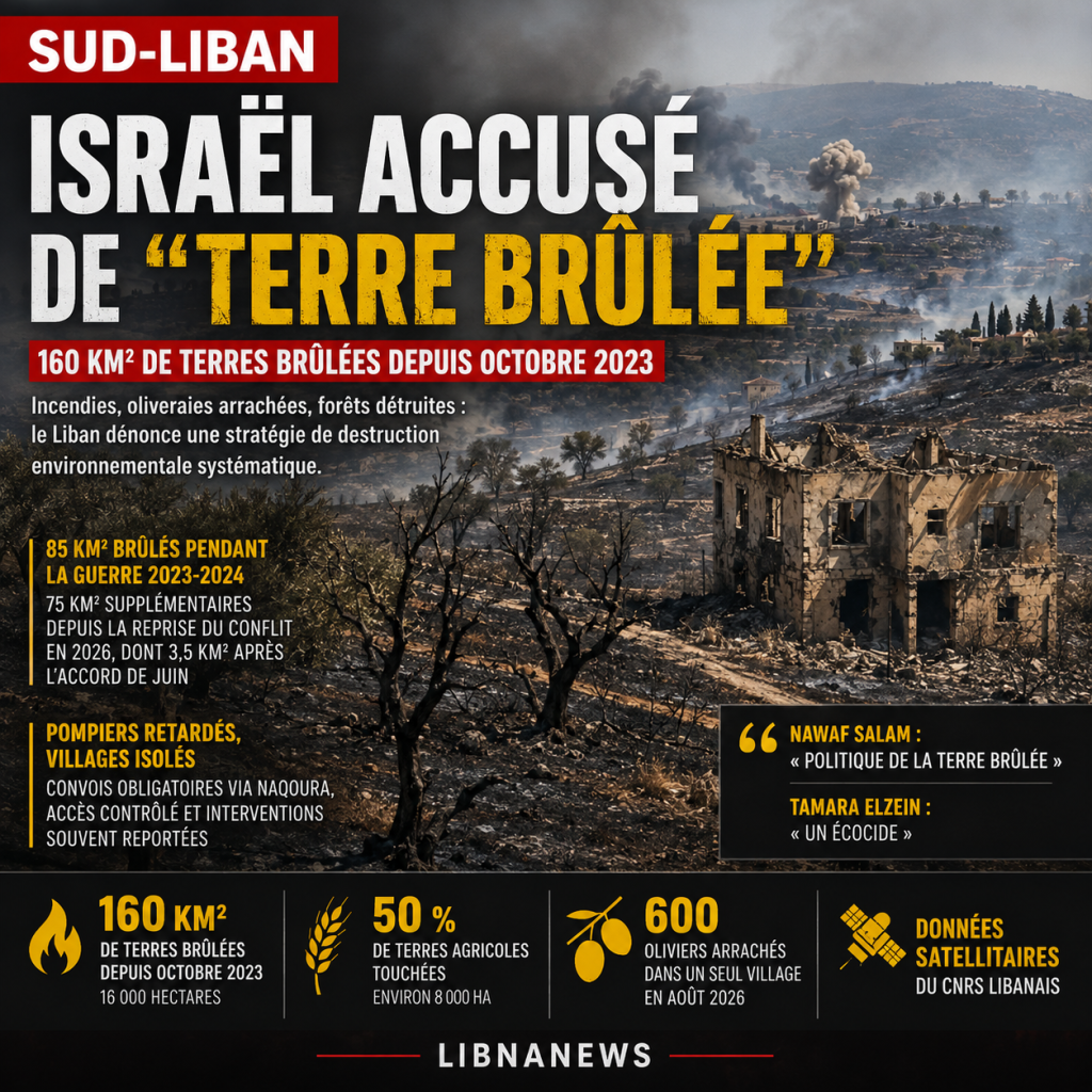
At least160 square kilometres of land burned in southern Lebanon since October 2023 as a result of Israeli military activitiesaccording to data from the Lebanese National Council for Scientific Research (CNRS). Half of the area affected would be agricultural. After 85 km2 burned during the war of 2023-2024, an additional 75 km2 have burned since the outbreak of the conflict in 2026, 3.5 km2 of which after the agreement reached in June. The Lebanese government now accuses Israel of applying a « scorched earth policy », while Environment Minister Tamara Elzein speaks of « ecocide ». Fires caused by bombardments, ripped vegetation, destroyed olive groves and delayed access for firefighters turn military damage into an environmental crisis whose consequences could last decades.
160 km2 of burned land in southern Lebanon
The figures give the measurement of destruction. The Lebanese CNRS estimates that160 km²either16,000 hectaresareas burned since the outbreak of clashes between Israel and Hezbollah in October 2023. About half of these are agricultural land, potentially close to8,000 hectares of crops, orchards and farmed landprotection caps (if present).
The destruction took place in several phases. According to Chadi Abdallah, director of CNRS, about8,500 hectares, or 85 km2, had burned during the war of 2023-2024. Since the resumption of the conflict in 2026, someadditional 7,500 hectares, or 75 km2, were burned. Among them, about350 hectares burned after the june israeli-lebanese agreementdespite the decline in the intensity of hostilities.
These data do not only identify natural fires observed during a summer marked by extreme temperatures. Lebanese scientists link the areas concerned to Israeli military activities. Satellite imagery compares pre-operation vegetated areas with burned, deforested or disturbed land after bombardment and ground response.
The main figures of destruction
| Indicator | Data |
|---|---|
| Surface burned since October 2023 | 160 km² |
| Equivalent in hectares | 16,000 ha |
| Estimated share of agricultural land | approximately 50% |
| Potentially affected agricultural area | approximately 8 000 ha |
| Surface burned during the war of 2023-2024 | 8,500 ha |
| Surface burned since the outbreak of conflict in 2026 | 7,500 ha |
| Surface burned after June 2026 agreement | 350 ha |
| Olivier torn up in one village in August | 600 |
These figures do not necessarily cover all environmental damage. The destruction caused by bulldozers, tree grubbing, soil degradation and damage to ecosystems are not all tantamount to burned areas. The actual ecological balance can therefore exceed that of the only fires detected.
Fires now deeper rooted in the territory
Fire geography has also changed. During the clashes of 2023 and 2024, the fires related to military operations remained mainly concentrated in the border band. According to CNRS, they have spread since the outbreak of hostilities in 2026.
Shadi Abdallah accuses the Israeli army of burning land « systematicly ». According to him, destruction tends to create a buffer zone free of « houses, inhabitants and the natural environment ». This interpretation is consistent with the political accusations made by the Lebanese authorities, but Israel rejects the idea of a policy deliberately aimed at the environment.
Field observations, however, show a significant concentration of fires in areas where Israeli forces operate. During the month of August, several fires were observed inside or near the area that Israel presents as a « security zone », deep about ten kilometres inside Lebanese territory along the border.
This military presence also complicates the fight against flames. Lebanese firefighters cannot systematically intervene immediately in areas close to Israeli positions. Sometimes they have to wait for safe coordination before approaching the fires.
In Houla, « they burned everything »
Satellite statistics take on a concrete dimension in border villages. Haidar Qoteish, 36, father of four, observes from Shaqra the land of his village of Houla, about five kilometres away and currently under Israeli military control.
« They burned everything. We see that the fields are completely black, » he says. According to him, plots that did not burn were sometimes upset by bulldozers.
For owners, the loss is not limited to an annual harvest. Orchards and olive groves are agricultural capital accumulated for several decades. An adult tree destroyed cannot be economically replaced by the mere planting of a young tree.
This difference distinguishes environmental damage from some property destruction. A house can theoretically be rebuilt when security and financial conditions permit. An old olive grove, a forest area or a Mediterranean ecosystem takes years or even decades to regain a comparable state.
» The destroyed houses may be rebuilt in a year, but the trees don’t grow back, » says Qoteish.
Bombs, drones and ammunition accused of firing
Lebanese Civil Defence states that it directly observes the link between certain military operations and the outbreak of fires. Hussein Fakih, Civil Defence Officer for the Nabatiyah region, reports that since July his teams have seen fires inside and near areas where Israeli forces are located.
He attributed some fire departures to Israeli bombardments and drones. He also referred to the use of phosphorus-fired munitions and submunitions in certain sectors.
White phosphorus had already generated significant environmental and humanitarian controversy during the previous clashes. This substance ignites in contact with oxygen and can cause fires when it falls on vegetated land. Its use is not prohibited under all circumstances by international law, but its use in or near civilian areas is subject to the rules protecting populations from the effects of incendiary weapons.
The possible presence of explosive remnants adds another risk. Affected land may remain hazardous after the fires have been extinguished, making it difficult for farmers, environmental teams and services to assess damage.
Kfar Shuba, a late-fighting fire
Kfar Shuba illustrates the consequences of this combination of fires and military restrictions. The locality is in contact with the Israeli-controlled area. According to its mayor, Qassem al-Qadri, an Israeli attack in August triggered a fire that spread over a vast area, mostly forested.
The inhabitants tried to fight the flames themselves. However, the specialized teams could not gain immediate access to the sector because of the coordination procedures in areas close to Israeli positions. They were to obtain a green light under the mechanism for monitoring the cessation of hostilities agreement.
According to Hussein Fakih, this authorization only arrived the next day. At that time, he said, the fire had already « burned everything. ».
The problem sometimes starts before the flames leave. In Kfar Shuba, owners of land near Israeli positions are reluctant to carry out the usual preventive work, such as brushing and cleaning dry vegetation. They fear that they will approach areas whose military boundaries they do not know exactly.
The mayor underlines this uncertainty. Israel evokes a « safe zone », but the inhabitants say they do not know exactly where it begins and where it stops. This lack of clearly identifiable boundaries reduces their ability to maintain their land and prevent fires.
Nawaf Salam accuses Israel of « burning land »
Faced with the scale of the damage, the Lebanese authorities have tightened their vocabulary. Prime Minister Nawaf Salam accuses Israel of leading a« politics of the burned earth »in southern Lebanon.
The expression refers not only to fires. It includes demolitions of buildings, the use of bulldozers, the grubbing up of trees and destruction of material conditions that allow people to return to border villages. Several localities underwent blasting and demolition operations in parallel with the bombings.
For Beirut, therefore, the issue is the very possibility of restoring sustainable civilian life in the areas concerned. Destroying a home causes immediate displacement. Degrading agricultural land, orchards and forests simultaneously can prevent the economic return of a family long after the end of military operations.
This dimension is particularly important in the South, where family farming is based on olive trees, fruit trees, tobacco and various local crops. Land is both a source of income and a component of intergenerational heritage.
Tamara Elzein denounces « ecocide »
Lebanese Environment Minister Tamara Elzein goes further. It describes environmental destruction as« ecocide »and accuses the israeli army of deliberately burning portions of lebanese territory.
The term has a strong political and legal significance, although its characterization in international law remains debated and does not automatically correspond to an offence recognized in all jurisdictions. Its use by the Minister aims to underline the massive and lasting nature of the damage found.
In particular, environmental authorities are seeking to document such destruction through satellite imagery and field surveys. This documentation is used to measure burned surfaces, as well as to monitor changes in vegetation cover.
The images studied by the CNRS show once green areas without vegetation. Some transformations result from fires, while others correspond to bulldozing or grubbing operations.
600 olive trees torn from one village
Fires thus represent only part of the problem. In August, Israeli forces snatched600 olive trees in a single village in southern LebanonAccording to information from the Lebanese National Information Agency.
The impact of such an operation exceeds the number of trees destroyed. An olive tree can produce for decades and survive centuries. In Lebanese rural areas, olive groves are a family heritage as well as an agricultural resource.
The grubbing-up immediately destroys the productive capacity of the plot. Replanting does not allow the lost yield to be recovered quickly, as several years are needed before a young tree reaches significant production.
At the village level, the combination of fires and stowage can therefore make a lasting difference to the agricultural landscape. The financial consequences will depend on the area actually exploited before the war, the number of trees lost, their age and the possibilities of returning homeowners.
Forests and nature reserves also affected
Agricultural areas are not the only ones concerned. The Lebanese environmental organization Green Southerners claims to have documented extensive damage to forests, forested areas and agricultural land in the South since 2023.
The association also warned in August about the damage suffered by large natural reserves. According to her, several protected areas have been destroyed « extended and repeated ».
Fires can profoundly alter Mediterranean ecosystems. The loss of vegetation further exposes soils to erosion, especially during heavy rains. It also affects habitats used by birds, mammals, reptiles and insects.
Repeating fires is an aggravating factor. Some Mediterranean plant species may regenerate after an isolated fire. However, close fires, associated with bulldozing and heavy equipment, can compromise this natural recovery capacity.
Israel claims to take precautions
The Israeli army implicitly rejects the accusation that it seeks to cause systematic environmental destruction. Asked about these fires, she says she is aware of the « potential environmental impact » of her operations.
It argues that these are conducted with « precautionary measures » to limit damage to civilians and the environment. This position is directly opposed to the accusations made by Lebanese officials and the country’s scientific authorities.
Israel also presents its operations in Lebanon as part of its security objectives against Hezbollah. The crucial question is therefore the nature of the destruction: the consequences of military operations according to the Israeli position, or the systematic strategy of transforming the border band according to Lebanese accusations.
Satellite data are used to establish the extent of burned areas and changes in the territory. However, they alone are not sufficient to establish legally the intention behind each fire. This distinction remains important when it comes to characterizing the facts.
A destruction that continues despite the June agreement
The calendar is one of the most sensitive elements of the file. The destruction continued with the reduction of hostilities and the June agreement between Israel and Lebanon. The CNRS estimates that350 hectares, or 3.5 km2, have burned again since this agreement.
Israel also continues to carry out strikes and demolition operations in southern Lebanon. Dynamitations were further reported on 25 August in several areas, including Haris, Ainata, Zawtar al-Sharqiya and Mais al-Jabal. Fires have also been reported in fields and olive groves.
This continuity feeds the Lebanese accusations of « scorched earth ». For those responsible, environmental damage can no longer be analysed solely as a consequence of the most intense phase of the 2023-2024 war.
The7,500 hectares burned in 2026this is in fact an area close to the8,500 hectaresthe previous phase of the conflict. The pace of environmental destruction is therefore one of the main elements highlighted by the CNRS.
An economic cost beyond the end of the fighting
Assessing financial losses remains difficult. The8,000 hectares of agricultural land potentially burneddo not have the same crops or yields. An old olive grove, an annual field and an unexploited parcel cannot receive the same economic value.
The cost cannot therefore be achieved by simply multiplying an area by an average price. It will be necessary to identify farms, identify crops, determine the age of trees, measure crop losses and integrate the years needed to restore production.
To this are added indirect losses. Some farmers can no longer reach their land. Others cannot clear their plots for fear of approaching Israeli positions. Fires and the presence of unexploded ordnance can also permanently delay recovery.
Thus, agricultural reconstruction could be slower than real estate reconstruction. Building a wall or house depends primarily on financing, materials and access to the land. Reconstitute an adult forest or olive grove also depends on biological time.
16 000 hectares that re-design the South
Reported territorially, the16,000 hectares burned since october 2023represent a considerable transformation of the border landscape. Half would be agricultural land, while forests, natural areas and other vegetated areas make up a significant part of the rest.
To this area are added the bulldozed areas that did not necessarily burn, the uprooted trees and the land that became temporarily inaccessible. The measurement of burned surfaces is therefore a major indicator, but not a comprehensive assessment.
CNRS continues to monitor by satellite while environmental organisms attempt to document ground damage. Such data could become essential for future reconstruction and compensation programmes, but also in the event of international legal approaches.
For the inhabitants, the calculation is more immediate. In Houla and neighbouring villages, the blackened fields are already visible. A destroyed house may eventually be rebuilt when the inhabitants return. The olive trees, orchards and forests that have disappeared will impose a much longer timetable: that of the years of growth needed to replace what has been destroyed in a few hours.
Environmental consequences that will be measured over several years
The final balance sheet can only be drawn up with full access to the sectors now occupied or difficult to access. Satellite images provide a first mapping of burned surfaces, but assessing soil quality, actual tree mortality and forest regeneration capacity requires on-site observations.
In particular, scientific teams will have to determine the extent to which repeated fires have affected the surface layers of the soil. The loss of vegetation increases the risk of erosion when rains resume. On sloping terrain, frequent in southern Lebanon, runoff can take some of the fertile soils and further slow the return of vegetation.
The issue of ammunition constitutes an additional obstacle. Before farmers can resume their activities, the land concerned must be considered sufficiently safe. Areas that have been bombed or suspected of having submunitions may require mine clearance and clearance prior to re-cultivation.
The consequences are as follows: immediate destruction of vegetation, loss of crops, impossibility of access to parcels, risks related to explosives and delays in the reconstruction of orchards. For some families, physical return to the village will not automatically mean returning to their economic activity.
The figures at the heart of a future reconstruction dossier
Data collected since October 2023 should also affect the future reconstruction of southern Lebanon. Damage cannot be calculated solely from the number of houses, roads or infrastructure destroyed. Agricultural and environmental losses will have to be included in the overall assessment.
The16,000 hectares burned, of which about half agricultural land, already provides an order of magnitude. But a serious financial estimate will require a much more detailed inventory. Each parcel will have to be evaluated according to its use, its crops, its previous yield and the duration of its return to production.
Olive trees illustrate this difficulty. The loss of a tree is not only its material value when it is torn or burned. It includes future crops which cannot be produced during the years necessary for its replacement, as well as income associated with the processing and marketing of olives and oil.
The same reasoning applies to forest areas, although their value is not only measured in terms of agricultural income. They play a role in soil protection, biodiversity and local hydrological balance. Their disappearance therefore entails environmental costs which are not immediately reflected in the economic balance sheets.
A battle around the qualification of destruction
The issue is now also political and legal. The Lebanese authorities use particularly serious terms. Nawaf Salam speaks of « scorched earth politics, » while Tamara Elzein denounces a « ecocide ». Shadi Abdallah, head of the CNRS, accuses Israel of seeking to create a buffer zone free of homes, populations and vegetation.
These accusations are based, among other things, on the repetition of fires, their geographical concentration and their association with military operations. The destruction of trees by bulldozing and grubbing up reinforces the Lebanese view that damage goes beyond the accidental consequences of fighting.
Israel presents a different reading. His army claims to consider the potential impact of its operations on the environment and to take precautions to reduce damage. It links its military interventions in Lebanon to its security imperatives and does not recognise the existence of a policy designed to systematically destroy the southern environment.
Establishing a possible legal liability would require more than a finding of damage. It would be necessary to document precisely the operations, identify the weapons used, determine the circumstances of each fire and, where deliberate destruction is alleged, provide evidence to establish its intent. In this context, Lebanese scientific data constitute a documentary basis, but not a judicial qualification alone.
The return of residents also depends on the return of land
Behind this battle of numbers and qualifications is finally the question of the return of populations. In much of southern Lebanon, land is a direct means of livelihood. A family can find a house still standing while discovering that its farm no longer exists or remains inaccessible.
This situation may exacerbate the demographic consequences of the war. If residents can no longer cultivate their land, rebuild their farms or move freely to their plots, some returns may be delayed even after a safe improvement. Environmental destruction becomes an additional displacement factor.
This is precisely what Lebanese officials fear when they talk about creating a buffer zone. Their accusation is that the combined destruction of homes, vegetation and livelihoods would make certain parts of the border band permanently difficult to live in.
This assumption will have to be confronted with the evolution of the terrain and the modalities of the Israeli withdrawal. But the material consequences are already measurable:85 km2 burned during the war of 2023-2024, an additional 75 km2 in 2026 and a total of 160 km2 since october 2023According to the CNRS.
In Houla, Kfar Shuba and other affected areas, the challenge is no longer just to extinguish the summer fires. It will be necessary to determine how many olive trees, orchards, forests and cultivable land have disappeared, how many more can be saved and how many years will be needed to restore an environment for their inhabitants to live there again.