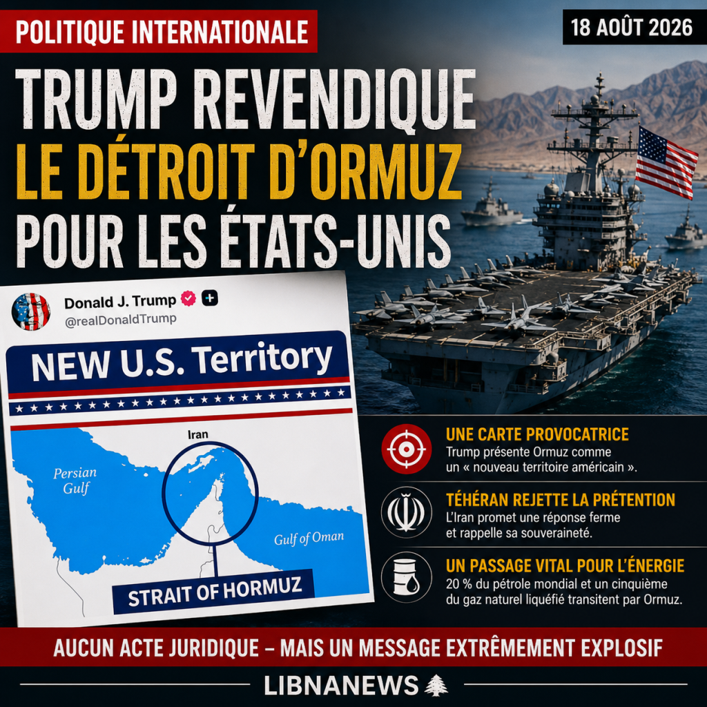
Donald Trump published Tuesday 18 August 2026 on Truth Social a map presenting theormuz Strait as a « new American Territory », a new step in the verbal escalation initiated by the President of the United States around this strategic maritime crossing between Iran and Oman. The publication is not accompanied by any legal act that may alter sovereignty over the Strait. However, it intervened after several statements in which Donald Trump claimed that Washington now controlled the passage through its military device and openly envisaged declaring it American territory. Tehran immediately rejected this claim. Beyond its provocative dimension, the image touches on one of the most sensitive points of the conflict between the United States and Iran: the control of a sea route essential to world oil and gas exports.
Trump Releases Map of American Ormuz Strait
The image published on August 18 on Donald Trump’s Truth Social account is explicit. A map shows the Strait of Ormuz, between the Persian Gulf and the Gulf of Oman, surrounded by a circle. The words « NEW U.S. Territory » or « new American territory » appear in large letters above. The area represented is in contact with the Iranian and Omani coasts, while the map also includes part of the maritime environment of the United Arab Emirates.
Donald Trump did not accompany this publication with any detailed explanation. It did not announce any treaties, legislative procedures or agreements with riparian states that could provide a legal basis for a U.S. territorial acquisition. The publication must therefore be distinguished from an effective modification of borders or maritime sovereignty.
However, it is not an isolated initiative. For several days, the U.S. President has been publicly preparing this idea. On 14 August, during a trip to New York, he stated that, after completing the confrontation with Iran, he could soon proclaim the United States strait territory.
On Monday, August 17, when questioned again in the Oval Bureau, Donald Trump reinforced his point. He had described this perspective as an excellent idea and affirmed that the United States controlled the Strait through the naval blockade. The map published the next day therefore transforms a series of oral statements into a visual political message addressed directly to Iran and the Gulf States.
A claim without immediate legal effect
Present thestrait of Ormuz as an American Territorynot enough to change its status under international law. The sea crossing is located between Iran in the north and Oman in the south. The two States have territorial seas in that area and exercise the rights attached to their maritime sovereignty within the limits provided for by international law.
The United Nations Convention on the Law of the Sea provides that a coastal State may dispose of a territorial sea of up to 12 nautical miles. It also covers straits used for international navigation and provides for a transit regime for ships and aircraft.
Oman declared a territorial sea of 12 nautical miles. Iranian legislation also claims a 12-mile territorial sea in the Persian Gulf, the Strait of Ormuz and the Oman Sea. Iran and Oman have also concluded maritime delimitation agreements.
An American naval presence, even large, does not automatically transfer sovereignty. The temporary military control of a waterway and the legal acquisition of a territory are two distinct concepts. No evidence published on 18 August establishes that Oman or Iran would have agreed to assign to the United States territorial rights in the Strait.
Tehran promises to respond to American « pretense »
The Iranian reaction soon followed. Iranian Deputy Foreign Minister Kazem Gharibabadi responded on August 18 to Donald Trump’s publication by rejecting his claim. He warned that the US President’s claims would either be corrected or face an Iranian response.
The Iranian official also noted that the map circulated by Donald Trump used the name « Persian Gulf », or Persian Gulf. Tehran attaches particular political importance to this name and regularly opposes alternative designations used in certain Arab countries or in Washington.
This reaction occurs after several days of particularly tense exchanges. Iranian officials argue that the decision to open or close the Strait is Iran’s responsibility, while Washington claims to be able to guarantee navigation through its military presence.
The conflict thus goes beyond Donald Trump’s vocabulary. Behind the map is a confrontation about Iran’s ability to disrupt navigation and that of the United States to guarantee the passage of ships despite Tehran’s opposition.
The Strait of Ormuz, the global energy artery
The importance of the Strait explains the international scope of this confrontation. This narrow seaway connects the Persian Gulf with the Gulf of Oman and the Arabian Sea. It is one of the main points of passage for global energy.
According to the U.S. Energy Information Agency, about 20 million barrels of oil and petroleum products per day passed through Ormuz in 2024, equivalent to about 20 per cent of global consumption of petroleum liquids. The passage also represented more than a quarter of the world’s maritime oil trade.
Gas is also involved. About one fifth of the world’s liquefied natural gas trade was transiting through the Strait in 2024, mainly due to Qatar’s exports.
However, data from 2026 show the impact of the conflict on these flows. In the first quarter, the volume of oil and petroleum products passing through Ormuz had fallen to about 14.6 million barrels per day, compared with over 20 million barrels per day in previous quarters.
Therefore, a lasting disturbance is far more important than Iran and the United States. Saudi Arabia, the United Arab Emirates, Kuwait, Iraq and especially Qatar depend to varying degrees on this road for their energy exports.
The United States itself is less directly dependent on Ormuz
One of the paradoxes of confrontation is that the US economy today depends less directly on Gulf oil than on many Asian economies. The United States imported about 490,000 barrels of crude oil a day from the Gulf countries in 2025. This represented about 8% of their U.S. crude oil imports.
The American issue therefore far exceeds domestic supply. Washington seeks to secure a road on which world markets depend, its Gulf allies and several major energy-importing economies.
A prolonged closure or disruption may result in an increase in world prices. Although the US produces a large amount of oil, US consumers remain exposed to variations in a widely globalized market.
Donald Trump’s claim thus directly affects international energy security. The mere prospect of a new confrontation around the strait can influence market expectations, the cost of shipping and ship insurance premiums.
A military confrontation that has become central for months
The 18 August publication comes in the context of the conflict that has been between Washington and Tehran for nearly six months. The Strait of Ormuz has gradually become one of the main strategic issues.
Donald Trump had already multiplied the declarations on the control of this seaway. In particular, he had referred to the possibility for the United States to retain the Strait and stated that the United States naval system now allowed Washington to control its access.
Tehran defends an opposite reading. Iranian officials have conditioned the complete normalization of navigation on the fulfilment of the commitments they assign to the United States under the arrangements negotiated between the two countries.
The UN Security Council has also seized the safety of navigation. In the context of the tensions of 2026, he reaffirmed the right of transit passage of ships and aircraft through the Strait in accordance with international law.
This dimension is essential: the principle defended at the international level is that of freedom of navigation in an international strait, not that of its appropriation by an external power.
Oman directly affected by Trump’s map
Geography also makes the American declaration particularly sensitive for Oman. The Sultanate is the coastal state of the southern shore of the Strait. Some of the waters crossed by the navigational routes are therefore under the regime applicable to Omani territorial waters.
Any US land claim would therefore not only concern Iran. It would also affect the sovereign rights of Oman, a Washington partner and traditional regional mediator.
This makes presidential rhetoric delicate for American diplomacy. The United States may want to militarily guarantee freedom of navigation without legally claiming the territorial waters of a partner State.
The map published by Donald Trump does not specify the exact limits of what he presents as the new American territory. It therefore does not determine whether it claims only a maritime area of passage or a wider portion of the strait. The lack of precision reinforces its political rather than legal character.
An image that prolongs diplomacy through provocation
Donald Trump regularly uses his social networks to announce, test or amplify diplomatic positions. In the case of Ormuz, the publication comes after several statements that are sufficiently explicit to exclude the hypothesis of a completely disconnected image from his political discourse.
It does not, however, make it clear that the United States has legally annexed the Strait. As of 18 August, no recognized procedure has transformed Ormuz into American territory and no change in sovereignty has been established.
The current situation therefore lies precisely in this contrast. The President of the United States publicly makes a land claim on one of the most strategic shipping routes in the world, while its international status and the rights of riparian states are not affected by this publication.
The Iranian response shows that Tehran nevertheless takes the message seriously enough to respond officially. The risk is that the symbolic battle around the map will overlap with military confrontation and negotiations on navigation.
As of August 18, 2026, the Strait of Ormuz did not become an American territory solely because of Donald Trump’s publication. But the President has taken a new step in his rhetoric by now presenting this claim not as a future possibility, but as a map directly displaying the words « new American territory ». The next key indication will be whether Washington transforms this presidential communication into a formal diplomatic claim or whether the White House keeps it on the register of political pressure.