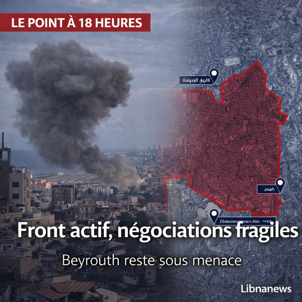


The Israeli army, with the voice of its Arab-speaking spokesman, Avichay Adraee, issued a new threat against several parts of the southern suburbs of Beirut, publishing a map marked in red and calling on the inhabitants to evacuate. The sectors mentioned include Haret Hreik, Ghobeiry, Laylaki, Hadath, Burj al-Barajneh, Tahuitat al-Ghadir, Shiyah and Jnah. In the following hours, the Lebanese media relayed the alert as a new phase of direct pressure on a dense urban area, already hit several times in recent weeks. The map shows a very wide grip, which covers most of the southern suburbs to the outskirts of Beirut International Airport.
The threat does not target an isolated point or a specific building. It covers a vast urban area, populated, nestled in the fabric of the capital, where tens of thousands of people live, including families displaced by previous bombings. The image broadcast and transmitted here shows a large continuous red area, bordered to the north by the area of the new road, east by Hazmieh and Baabda, and south-west by Rafic Hariri airport. This immediately changes the nature of the message: it is not a limited warning, but a mass threat on the southern suburbs. This reading stems from the visible content of the map provided and from information relayed by MTV Lebanon on the Israeli evacuation order.
In a context already marked by the most violent Israeli strikes of this phase of war, this new warning adds a further degree of panic and uncertainty. For every publication of Avichay Adraee is now read, in Lebanon, not as a mere military communication, but as a possible prelude to bombings on inhabited neighbourhoods. The inhabitants of the southern suburbs no longer receive these maps as technical documents. They read them like countdowns. That is what gives this sequence a political, human and urban reach far beyond the Israeli message itself. This latter assessment is based on an analysis based on the contents of the evacuation order and on previous documented strikes after publication of similar warnings.
Explorez la carte en direct des evenements et points de situation.
The neighbourhoods targeted by the Israeli threat
The list of sectors mentioned is clear and particularly meaningful. These are Haret Hreik, Ghobeiry, Laylaki, Hadath, Burj al-Barajneh, Tahuitat al-Ghadir, Shiyah and Jnah. MTV Lebanon relayed an Israeli alert against the « southern suburbs » of Beirut, with explicit reference to several of these neighbourhoods, including Tahuitat al-Ghadir and Shiyah. Previous publications and media coverages in the past month had already shown that Haret Hreik, Burj al-Barajneh, Hadath and Shiyah were among the areas regularly designated in Israeli evacuation orders.
This point is essential because it shows that the current warning does not arise in a vacuum. The same names come back from week to week, sometimes with expanded perimeters. Haret Hreik is one of the historic heartlands of the southern suburbs. Ghobeiry connects several dense residential and commercial areas. Laylaki and Tahuitat al-Ghadir are heavily populated areas. Burj al-Barajneh and Shiyah are affected by mixed areas and key areas of passage. Hadath connects the southern suburbs to the east of the capital. As for Jnah, his mention further broadens the scope of the message, bringing the threat of the coastal axes and the south-west entrance to Beirut closer together. This geographical description is an analytical synthesis based on the map provided and the sectors cited in the orders relayed by the media.
Designation of these neighbourhoods together changes the scale of the problem. It is no longer only the Dahieh in its political or symbolic meaning that is targeted. It is an entire urban continuum. The red card doesn’t separate pockets. It draws a coherent territorial mass, which gives to see a southern suburbs treated as a single potential military space. From a journalistic point of view, it is probably the most important element of the sequence: Israel does not threaten a building, it threatens a zone of life. This interpretation is directly supported by the map transmitted and the general wording of the warning relayed by MTV Lebanon.
A red map that turns the southern suburbs into a global target
The distributed image plays a central role. Visually, it works as a large-scale bullying message. The coloured surface in red covers a very large part of the urban fabric south of Beirut. The airport is immediately visible on the edge of the area. The sea runs west of this right of way. In the north and east, the markers show that the target area is approaching traffic spaces, mixed neighbourhoods and areas where the daily life of the capital continues despite the war. In other words, the document submitted by the Israeli army does not isolate a military infrastructure identifiable by the general public. It covers an entire urban territory. This description is based on the image provided by the user.
In practice, such a card produces several simultaneous effects. She creates a psychological shock first. It then leaves the inhabitants a very small margin to understand if they are directly concerned, if they have to leave, where they can go and where they can go. Finally, it prepares the narrative ground for a possible strike by allowing Israel to say that a warning had been given. It is precisely this logic that makes these publications so dreaded in Lebanon: they shift the apparent responsibility on the affected civilians to move in emergency, even though they live in dense neighbourhoods, often with elderly people, children, wounded or limited means of transport. This analysis is based on the type of order relayed by the Lebanese media and the urban features visible on the map.
The map is also used to politically redefine space. By colouring such a vast grip, the Israeli army no longer refers only to Hezbollah infrastructure, according to its usual terminology. In its opinion, the whole southern suburbs constitute a homogeneous block, a safe exception area, almost a separate territory. This is where the message becomes dangerous beyond the immediate threat. It erases the complexity of the city, the social diversity of neighbourhoods, the presence of civilians, shops, schools, residential buildings, roads and services. It reconstructs urban space as a global target. This last sentence is an analysis based on the map representation provided in the image.
A threat that fits into an already documented series
This alert is not the first. MTV Lebanon has already relayed several Israeli warnings in late March and early April targeting the southern suburbs. On 25 March, the channel reported an Israeli airstrike warning on the southern suburbs. At the beginning of March, other evacuation orders had already concerned Haret Hreik, Bourj el-Barajneh, Hadath and Shiyah. On 8 April, according to an AFP dispatch taken over by other media, the Israeli army again called on the inhabitants of the southern suburbs to evacuate, in what was presented as its third warning since the announcement of the ceasefire between Washington and Tehran.
This reminder is essential to avoid reading the event as an exception. For several weeks, the method seems to be stabilized: distribution of a map or a list of sectors, immediate evacuation, and then threat or targeted strike in designated space. This created a particular temporality in the southern suburbs, consisting of brutal notifications, precipitated departures, saturated traffic, uncertain return and constant anxiety. Today’s threat must be included in this continuum. She’s not a breakup. It is the continuation of a repeated urban pressure strategy. This reading is supported by earlier alerts relayed by MTV Lebanon and other media coverage of the same neighbourhoods.
The return of the same names also shows that some neighbourhoods have become recurring targets of Israeli communication. Haret Hreik and Chiyah, for example, appear several times in evacuation orders. This means that the pressure does not stop after an alert. It recycles, repeats itself and maintains a state of permanent potential displacement. For the inhabitants, this repetition has a devastating effect. Even without immediate strike, she uses ordinary life. It turns every evening, every morning, every rumor into a risk of instant exodus. This latter assessment is analytical but consistent with the documented repetition of warnings.
What the presence of Jnah and the surroundings of the airport means
The mention of Jnah and the obvious proximity of the airport on the map are of particular importance. They extend the psychological scope of the threat to areas that touch vital axes for Beirut and the country. Rafic Hariri International Airport is visible in the image, at the very edge of the shaded area. This does not imply that the airport is directly targeted. But this means that the Israeli threat is unfolding in the immediate vicinity of one of the most sensitive points of Lebanese infrastructure. This observation is based on the card provided by the user.
On the ground, this neighborhood counts a lot. The more the threatened area descends towards Jnah and the vicinity of the airport, the closer the pressure is to a national strategic node. Even when warnings do not explicitly mention airport infrastructure, the mere fact that red reaches this border is sufficient to increase the fear of wider paralysis, major disruption of travel or a new episode of panic in the capital. It is also what makes these maps so powerful: they do not just designate a neighbourhood, they threaten the general balance of the city. This reading is an analysis based on the visible proximity between the red zone and the airport on the provided image.
Jnah’s presence is also politically significant. It suggests that the Israeli message is not limited to the stronghold usually associated with Hezbollah, but that it bites on hinged areas of passage and contact with the rest of Beirut. This reinforces the perception of extending the threat zone to wider and more mixed spaces. In the logic of a city like Beirut, these border areas are crucial. Threatening them means increasing the effect of sideration far beyond the directly named neighbourhoods. This last sentence is a geographical and political reading of the map provided.
A message from Adraee that is also part of psychological warfare
In Lebanon, Avichay Adraee is no longer seen as a mere military spokesman. It has become one of the most visible instruments of Israeli psychological warfare. Each of his publications is expected, scrutinized, feared. When publishing a map or a list of neighbourhoods, the message immediately exceeds the military framework. It affects schools, shops, families, transportation networks, hospitals, ambulances, traffic and collective psychology of an entire city. MTV Lebanon presented this publication as an « emergency Israeli warning », which shows that even in the media language, the primary effect is that of urgency and alarm.
The effectiveness of this method is due to its simplicity. Red card, some neighborhood names, order to leave. In a dense city, this is enough to disrupt civilian life. Those who can leave are rushing. Those who cannot remain in uncertainty. Those who are already displaced still have to move. Roads are saturating. Social media amplifies panic. The media interrupt their programming. And all this happens before a bomb falls. It is in this sense that the threat is already, in itself, as a war operation. This assessment is based on an analysis of the practical operation of evacuation warnings in a dense urban area.
It should also be stressed that this method re-designs the relationship between the Israeli army and Lebanese civilians. By issuing its warnings directly on the networks and through its spokesman, Israel addresses the inhabitants as if it were administering a territory under duress, telling them where to go, when to leave, what neighborhoods empty. The process produces a form of discursive domination over the city. It is also for this reason that he is living in Lebanon as humiliating, in addition to being terrifying. This analysis is based on the very nature of the broadcast message and the type of control it claims to exercise over civilian movements.
What this threat changes for Beirut
The publication of this map does not only concern the neighbourhoods mentioned. It changes the atmosphere of the entire capital. Because the southern suburbs are not a closed enclave. It is integrated in Beirut by roads, work, family ties, daily travel and urban geography. When Haret Hreik, Ghobeiry, Laylaki, Hadath, Burj al-Barajneh, Tahuitat al-Ghadir, Shiyah and Jnah are placed under simultaneous threat, it is the whole city that is entering a new alert phase. This reading is based on the urban continuity visible on the map and on the role of the neighbourhoods mentioned in the whole beyrouthin.
Perhaps the most serious is here. Israeli order transforms a living space into a space of suspension. He tells the inhabitants that their neighborhood can stop being habitable any minute. He tells Beirut that part of his fabric can be placed under global threat by a simple publication. And he once again recalls that in this war, military communication is not separated from violence: it is one of the preludes, one of the instruments and one of the extensions. This last sentence is an analytical synthesis based on the content of the warning and its previously documented.