





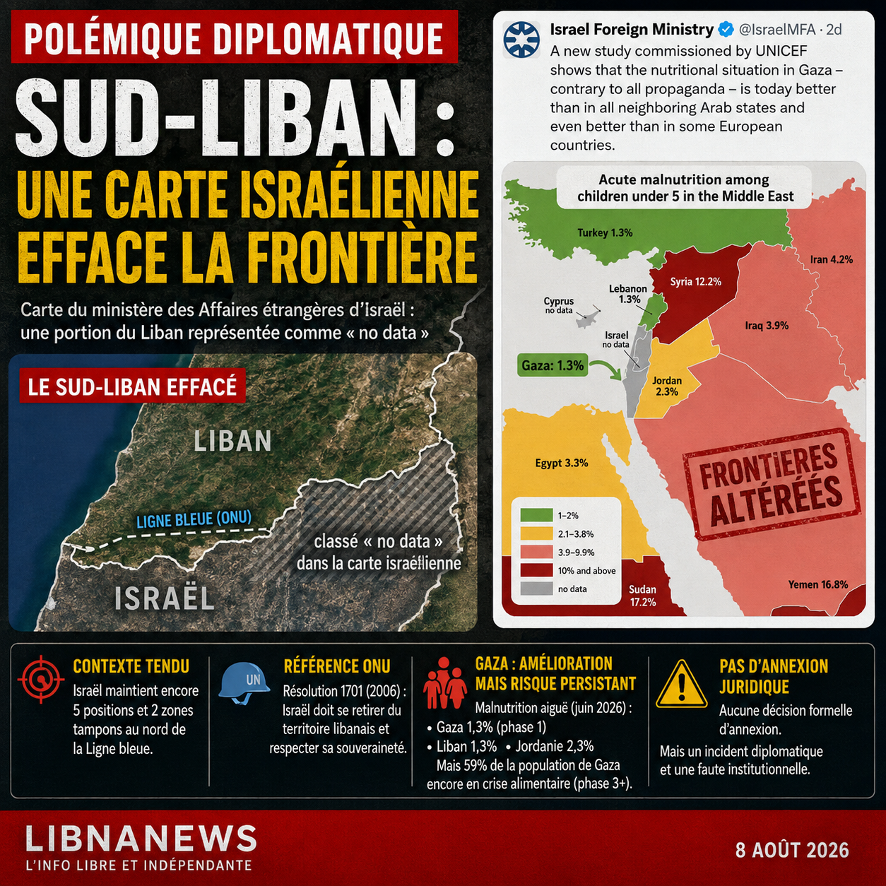
A map published in early August 2026 by the official account of the Israeli Ministry of Foreign Affairs provoked a controversy that went far beyond the subject it was supposed to illustrate. Disseminated on X in a message about child malnutrition in the Gaza Strip, the visual distorts several borders of the Middle East and reveals part of theSouth Lebanonin a graphic set distinct from the rest of Lebanese territory. The publication comes from an official channel of the Israeli state, but there is no evidence that it constitutes a legal declaration of annexation or that it was personally signed by the minister. However, it raises a sensitive diplomatic question: when a foreign ministry disseminates a map that alters the borders of a neighbouring state, cartographic error becomes an act of political communication that can be interpreted as a challenge to its sovereignty. In the Lebanese-Israeli context, marked by the Israeli military presence north of the Blue Line and by negotiations that were still fragile in 2026, this representation of southern Lebanon is of particular significance.
Israeli Ministry Releases Map that Amplifies Lebanon
However, the official Israeli message was not about Lebanon. He claimed that a new UNICEF-related study showed a better nutritional situation in Gaza than in several neighbouring Arab countries and even in some European countries. In support of this claim, the ministry shared a map entitled « Acute malnutrition among children under 5 in the Middle East ». Several countries are associated with acute malnutrition rates, including Lebanon at 1.3 per cent, Jordan at 2.3 per cent, Egypt at 3.3 per cent, Iraq at 3.9 per cent, Iran at 4.2 per cent, Syria at 12.2 per cent and Yemen at 16.8 per cent. Gaza is also shown at 1.3 per cent. It is this map, intended to support an argumentation on Gaza, which opened a second controversy: that of the geography it presents.
The problem is visible without extensive technical expertise. The forms of States, their coasts and several of their borders are altered. The Red Sea practically disappears from the drawing. Egypt is displaced and distorted. The representation of the Arabian Peninsula does not correspond to the actual geography. In the Levant, the boundary between Israel and Lebanon is confused. A portion of the territory in southern Lebanon appears absorbed in the grey area used on the map for areas marked « no data », including Israel. The visual does not simply simplify a border: it blurs the territorial continuity of Lebanon and produces the impression of an amputated South Lebanon.
A « map annexation », but not a legal annexation
This anomaly is all the more sensitive as the visual was not published by an anonymous account or an activist. It is on the official account of the Israeli Foreign Ministry. An institutional publication commits the communication of an administration, even when it results from a graphic error. This does not automatically turn a bad map into a territorial decision. Under international law, annexation involves actions that are otherwise more specific: claimed exercise of sovereignty, legislative or governmental decision, administrative incorporation of territory or explicit proclamation. None of these elements appear in the message on malnutrition in Gaza.
The formula of cartographic annexation therefore describes the phenomenon better than that of « declaration annexation ». It translates the effect of the visual without assigning it a legal value that it does not have. This distinction is essential. An official map can have strong political, symbolic and diplomatic significance. It can also be invoked in a debate on the intentions of a government. But it alone does not alter an international border and does not imply any external recognition of a new sovereignty.
Blue Line remains United Nations reference
In the caseSouth Lebanonsensitivity is reinforced by the situation on the ground. The United Nations Blue Line serves as a reference to the Israeli withdrawal from Lebanon and to monitor violations on both sides. It is not presented by the United Nations as a permanently delimited international border in all its segments, but it is the central operational landmark between Lebanon and Israel. Security Council resolution 1701, adopted on 11 August 2006, reaffirms the sovereignty and territorial integrity of Lebanon and provides for the withdrawal of Israeli forces from southern Lebanon in parallel with the deployment of the Lebanese Army and UNIFIL.
Twenty years later, this architecture remains at the heart of the case. In March 2026, the United Nations Interim Force in Lebanon reported that the Israeli army maintained five positions and two buffer zones within Lebanese territory. UNIFIL described this presence as a violation of resolution 1701. It also reported Israeli crossings near Markaba, Aadeysse, Kfar Killa and Ramya. A few months earlier, the mission had confirmed that a concrete wall built south-west of Yarun crossed the Blue Line and made more than 4,000 square metres of Lebanese territory inaccessible to the inhabitants.
These elements give any cartographic representation of southern Lebanon a special burden. An error committed by an Israeli ministry is not received in the same environment as an error published in a school atlas without immediate political context. It comes at a time when the United Nations is still calling on Israel to withdraw completely from the areas north of the Blue Line. On 24 April 2026, the UN Secretary-General renewed this appeal. He repeated it on 4 June, after a new round of negotiations between Lebanese and Israeli representatives in Washington.
A graphic error in an explosive territorial context
The publication of the Israeli ministry therefore comes at a time when the status of the ground, military positions and Lebanese sovereignty remain active subjects of negotiation. It is precisely this context that turns a graphic anomaly into a potentially diplomatic incident. For Beirut, any official map suggesting that part of southern Lebanon would be outside the national territory directly affects a question of sovereignty. For Israel, if the design is a manufacturing error, then its correction and clarification becomes an issue of institutional credibility.
The fact that the map has other major errors, however, calls against too literal a reading of each of its borders. Several Internet users quickly noted the disappearance of the Red Sea, the unlikely geometry of Egypt and the non-existent territorial neighborhoods. These defects give the visual the appearance of a map produced or retouched with automated tools, without rigorous cartographic control. It is not possible, from the image alone, to establish what technology was used in its creation. It would therefore be imprudent to say that it was generated by artificial intelligence. However, its geographically defective character is obvious.
This accumulation of errors reduces the possibility of seeing a territorial document prepared as an official diplomatic card. A ministry that wishes to announce a claim to sovereignty would normally use precise outlines, consistent terminology and explicit political text. Here, the message is about nutrition in Gaza, while the map serves as a comparative illustration. The Lebanese anomaly thus appears more as a lack of publication than as the legal form of a territorial claim. But the institutional origin of the message prevents us from considering this fault entirely anomaly.
Gaza: A second controversy over malnutrition figures
The controversy is also fueled by the way the Israeli account presents nutrition data. The message states that the situation in Gaza would now be better than in all neighbouring Arab States. However, the figures for acute malnutrition can only be compared properly if the surveys cover compatible populations, periods, methods and indicators. The map itself does not give detailed dates, methodology or directly visible references for each country. It places side by side values that may come from different years and different statistical devices.
The figure of 1.3 per cent associated with Lebanon corresponds in particular to a result documented in the LIMA survey conducted in Lebanon. The survey reported a national prevalence of emaciation of 1.3 per cent among children under the age of five, while raising much higher levels in some subgroups. It also reported a significant increase in stunting, with a national prevalence of 14 per cent. These indicators do not describe the same form of malnutrition and cannot be interchangeable.
Improving Gaza does not mean ending the crisis
For Gaza, the recent situation is also more complex than the Israeli ministry’s message. The CPI analysis published on 23 July 2026 indicates a significant improvement in acute malnutrition between mid-April and the end of June, following the increase in humanitarian and nutritional aid since the ceasefire of October 2025. The governorates analysed were then classified as phase 1, « acceptable », for acute malnutrition. Rafah had not been classified for lack of sufficient data. But the CPI projects a degradation to phase 2, known as « alert », between July and December 2026.
Measured improvement does not therefore mean that the nutritional risk is eliminated. The CPI estimates that approximately 74,200 children aged 6 to 59 months may require treatment for acute malnutrition until April 2027, including over 11,400 severe cases. The organization also estimates that 24,600 pregnant and nursing women may suffer from acute malnutrition during the same period. In its own July 2026 comment, UNICEF stresses that progress remains fragile and dependent on continued humanitarian access, food aid and nutrition programmes.
The overall food situation remains even worse than the only indicator of acute malnutrition among young children. Between mid-April and 30 June 2026, more than 1.2 million people, or 59 per cent of the population analysed in the Gaza Strip, were in phase 3 or more of acute food insecurity, corresponding to a crisis or worse situation. Approximately 212,000 people were classified in phase 4, known as emergency. For the period from July to December, the projections refer to more than 1.4 million people, or 67 per cent of the population, in crisis or in a more severe situation.
These data do not invalidate the improvement observed since the ceasefire. Rather, they show why the single figure of 1.3 per cent cannot summarize the humanitarian situation in Gaza. Acute malnutrition, food insecurity, mortality, access to water, infectious diseases and access to care are distinct dimensions. A low rate at a given date may coexist with a population heavily dependent on aid or exposed to rapid worsening if supplies are reduced.
Two polemics in the same official publication
The debate on the map thus has two different levels which must not be confused. The first concerns the political use of nutritional data and the comparison between Gaza, Lebanon and other countries. The second concerns the territorial representation of Lebanon by an official Israeli body. The first requires a methodological reading of the data. The second raises a question of institutional responsibility and respect for territorial representations in a region where borders remain at the centre of military tensions.
At the diplomatic level, the second level is probably the most sensitive for Lebanon. A map from the Ministry of Foreign Affairs is not a simple graphic content without identifiable author. The ministries use their official accounts to express positions, respond to foreign governments, issue press releases and defend their State policy. This official quality necessarily gives more weight to what they publish. It therefore justifies that an alteration of Lebanese territory should be examined and, where appropriate, explained or corrected.
However, it does not automatically assign the message to the Israeli Foreign Minister in his personal capacity. The available capture shows the Israeli Foreign Ministry institutional account. There is no visible individual ministerial signature. A message published by an administration falls within the official communication of that administration, but the distinction remains important when assessing the legal or diplomatic scope of a document. Talking about a « annexation declaration signed by the Minister » would therefore go beyond what the publication makes possible.
Why the word « annexion » requires distinction
The term annexation also implies a precise legal reality. Israel has, in its history, adopted explicit legislative or administrative measures when it intends to apply its right to occupied or claimed territories. A poorly designed map does not present this nature. No text accompanying the visual states that southern Lebanon belongs to Israel. No change in status is announced. No normative act is mentioned. At this stage, the document must therefore be treated as an official publication containing an erroneous or disputed territorial representation, not as a legal act annexation.
This does not prevent the « map annexation » formula from having a descriptive meaning in the public debate. It refers to the fact that one territory disappears visually from the map of one State and is incorporated into another graphic set. In a context of conflict, this practice can be seen as a form of symbolic normalization of a claim, even if the intention is not demonstrated. Any rigorous analysis must then separate three levels: what the image shows, what the accompanying text affirms and what the law allows to be inferred from it.
What the image shows is problematic: South Lebanon is poorly represented and several regional borders are false. What the text says is different: it seeks to challenge the story of a nutritional crisis in Gaza, based on an international comparison. What the right allows to be inferred from it is much more limited: no annexation of South Lebanon can be established on that basis alone. The Department’s political responsibility therefore begins with the dissemination of a defective geographical document from an official diplomatic account.
A communication that shifts the controversy from Gaza to Lebanon
The episode also illustrates the risks of government communication based on rapid infographics. A rate error can distort a health debate. A border error can cause a diplomatic incident. In this case, the two risks combine. The ministry wanted to defend a reading of the humanitarian situation in Gaza; His visual moves attention to Lebanese sovereignty and the quality of his own data. The map thus becomes a political object independent of the message that it had to support.
For Lebanon, the stakes go beyond the digital polemic. The Lebanese authorities continue to demand Israeli withdrawal from all positions north of the Blue Line and full respect for national sovereignty. The United Nations repeated this request in 2026. Any official representation that blurs this line therefore comes on an already concrete file, with soldiers, fortified positions, walls and territories whose access remains contested.